

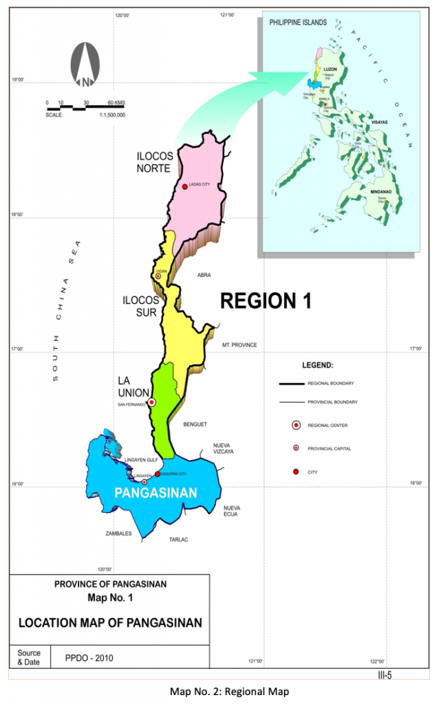
Geographic Location and Territorial Jurisdiction
The Municipality of Aguilar is one of the municipalities in the Province of Pangasinan.
It is a landlocked agricultural municipality, located about 191.1 kilometers North of Manila, about 38.7 kilometers from Dagupan City and some 25.6 kilometers from Lingayen, the provincial capitol
It lies in Pangasinan of Region 1, with geographic coordinates of 15o 53’ 20” North; 120o 14’ 19” East.
It is bounded on the east by San Carlos City, on the North by Bugallon, on the South by the Municipality of Mangatarem and on the east by Urbiztondo, and on the west by Sta. Cruz, Zambales.

Political Boundaries
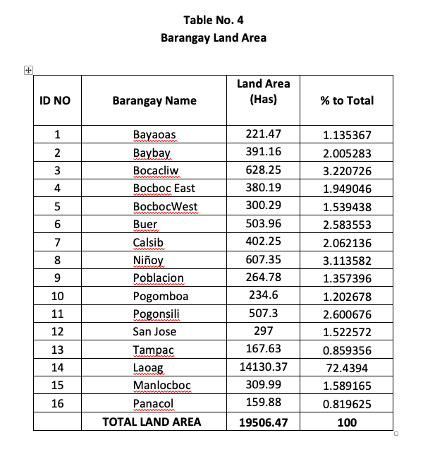
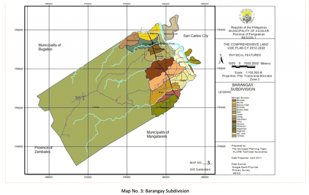
Aguilar has a total land area of 19,506.47 hectares politically subdivided into sixteen barangays.
The following are the sixteen (16) component barangays:
-Urban Barangays comprising the Poblacion, Laoag, Pogomboa and Baybay with a total land area of 15,020.90 hectares of which Laoag got the chunk of 14,130.37 hectares.
The remaining land area of the town, totalling to 4,485.56 hectares, is distributed into the rural brgys namely: Bayaoas, Bocacliw, Bocboc East, Bocboc West, Buer, Calsib, Niñoy, Pogonsili, San Jose, Tampac, Manlocboc and Panacol.
Table below shows the chunks in terms of area per barangay with Laoag as the largest with Panacol as the smallest.
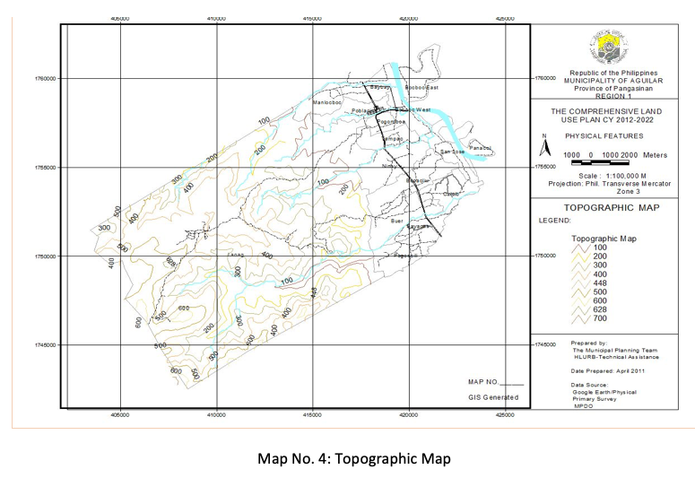
Topography
Aguilar is generally characterized by flat to gently sloping terrain; the highest peak in the area soars to 600 meters above sea level.
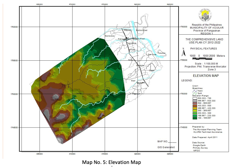
2.3.1. Elevation
By simulation from the topographic map with elevation ranges from 8-600 meters above sea level. Geographic Information System (GIS) however, produced an elevation map which shows a lowest elevation of 8 meters and the highest is 700 meters save those built-up areas that are generally flat.
2.3.2. Slope
There are five (5) slope categories in the municipality:
gently sloping, 0-10%
undulating, 10-20%
undulating to moderately steep, 20-30%
moderately steep, 31-50% and
very steep, 50% above

Soil
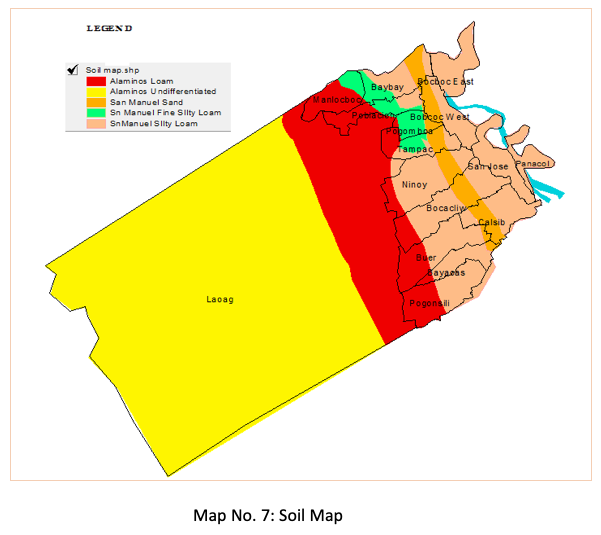
Soil Type
There are five (5) soil types in the Municipality
– the Alaminos Loam;
– Alaminos Undifferentiated;
– San Manuel Sand;
– San Manuel Fine Silty Loam and
– San Manuel Silty Loam.
Large portion of the town is covered with Loam soil which is composed of sand, silt and clay in relatively even concentration (about 40-40-20. It generally contains more nutrients and humus than sandy soils characterized with better infiltration and drainage than silty soils. It is easier to till than clay soils. It is gritty and retains water easily, basically suitable for growing crops hence, the town being predominantly agricultural.
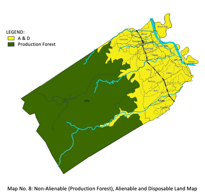
Non-Alienable (Production Forest) & Alienable and Disposable Land
Over 8,580 hectares was classified as non-alienable and non-disposable land as the same was declared public land/production forest in its land use by the DENR.
Alienable and disposable land totals to 10,926.47 hectares representing various land uses such as commercial, agricultural, residential, industrial, institutional and other uses.
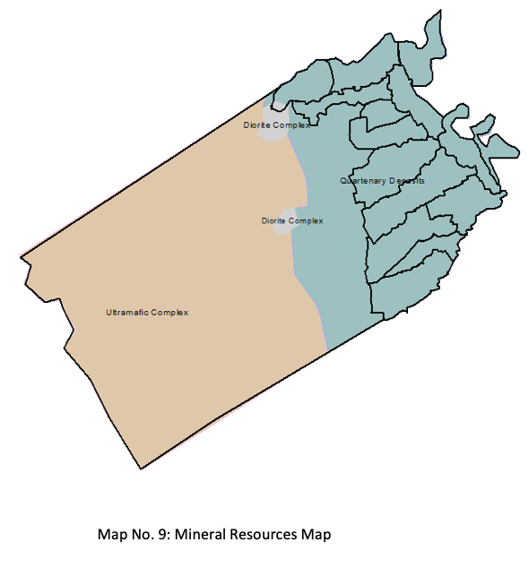
Mineral Resources
Mineral Resource which is a volume of rock enriched in one or more useful materials has three different types in the municipality – the Diorite Complex, Quartenary Deposits and Ultramatic Complex.
Quarternary deposits- refer to geological deposits typically of Quartenary Age. These unconsolidated sediments may include stream channel and floodplain deposits, beach sands, talus gravels and glacial drift and moraine. This is the most abundant in the LGU.
CLIMATE CHANGE/DISASTER RISK
D.1. Climatological Condition
D.1.a. Type of Climate and projection
The Municipality of Aguilar falls under type 1, which is characterized by two (2) seasons, dry season from November to April and the wet season from May to October.
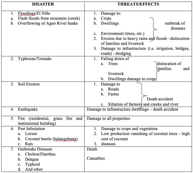
Heavy rainfall usually starts on the month of July up to September, causing floodings to those areas along Agno River and erosion as well on agricultural areas along the riverbanks.
Average temperature is around 27.91ºC with the highest occurring in May and the lowest in January.
D.1.b. Average Annual Rainfall
In general, most provinces in of Region 1 will experience heavy thunderstorms, lightning and heavy rains due to its topographic and climatic conditions.
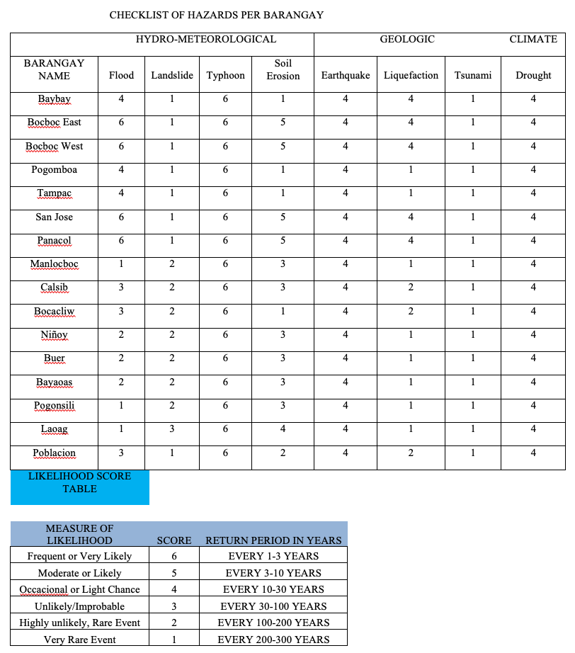
D.2. Hazards
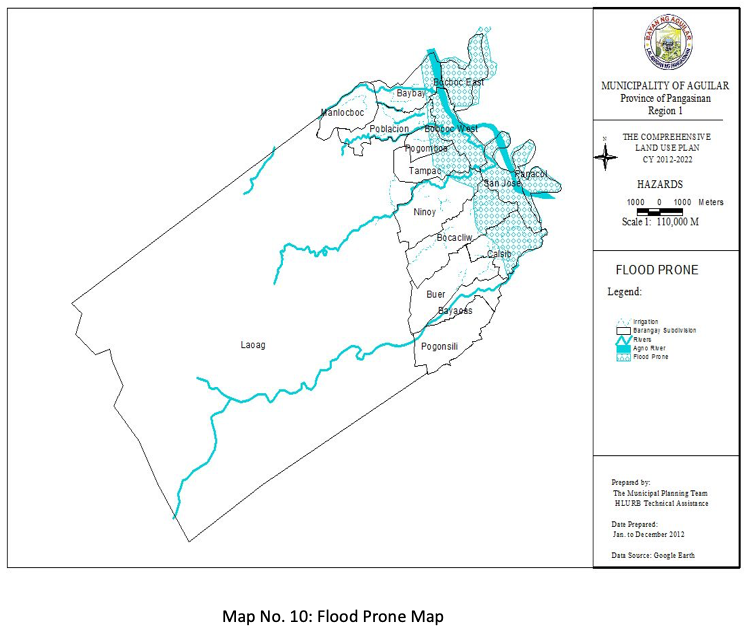
D.2.a. Flooding
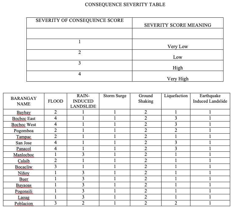
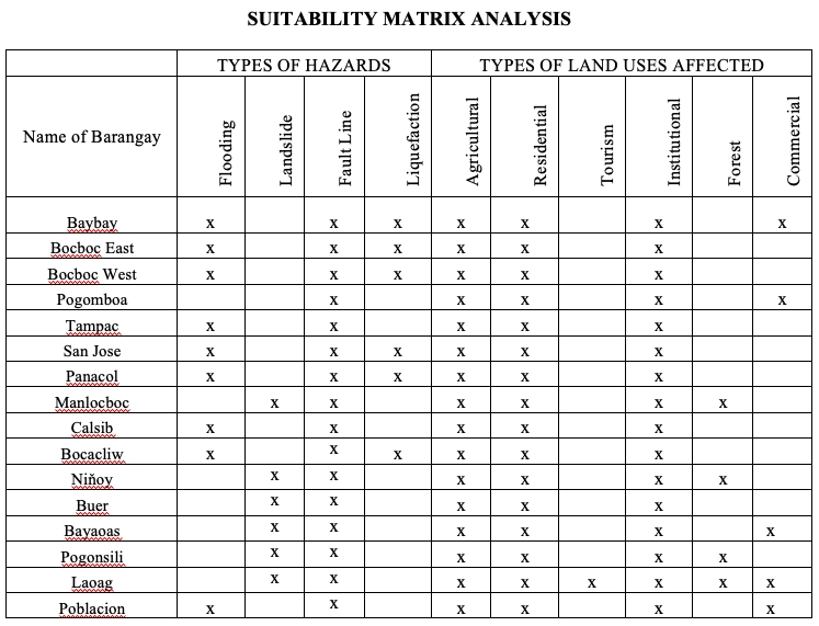
Flooding occurs along the eastern portion of the municipality being traversed by the Agno River. Affected areas are barangays: Bocboc East, portion of brgy. Baybay, portion of brgy. Poblacion, brgys Bocboc West, San Jose, Panacol.
Aside from the floodings brought about by Agno River, flash-floods is also being felt by some barangays due to its denuded forest, it is being experienced at barangay Poblacion, Pogomboa, Buer, Bayaoas and part of Baybay.
The Bayaoas Creek, Quiray Creek, Cagubay and Sobol Creek are already shallow due to siltation so that rainwater from the mountains easily overflow the banks that caused instantaneous flooding during rainy season.
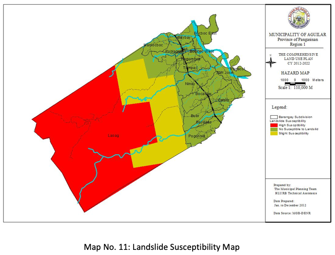
D.2.b. Landslide-prone areas
Portion of barangay Laoag is High Susceptible to landslide. Low to moderate landslide in barangays Manlocboc, Ninoy, Buer, Pogonsili and Bayaoas. Based on GIS simulation and data gathered from the Mines and Geosciences Bureau-DENR.
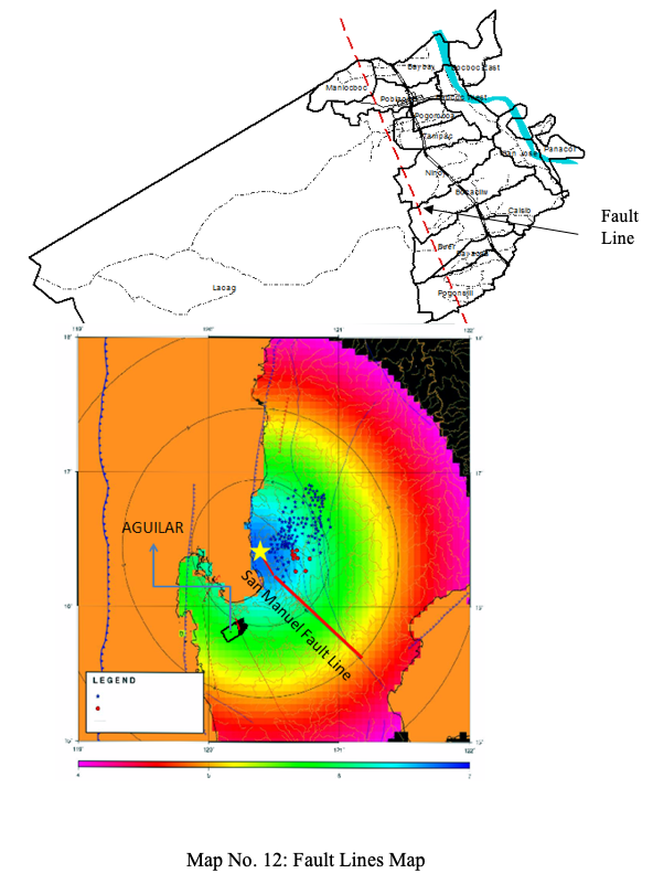
D.2.c. Fault Lines
The Municipality of Aguilar is being traversed by the East Zambales Faultline.
Another fault line is the San Manuel Fault located at the eastern part of the Municipality about 58,000.000 meters or 58 kilometers away from the municipality. A ground shaking simulation of the effect when these active fault line moves or an earth movement, all of the barangays will feel intensity (PEIS) 6, based on the strongest earthquake in 1984 a magnitude of 7.8.
D.2.d. Liquefaction
Barangays Bocboc East, Bocboc West, Panacol, San Jose and portions of Tampac, Ninoy, Calsib, Bocacliw, Pogomboa and Baybay are prone to liquefaction; this is because of the Agno River and other water tributaries within the municipality, covering a land area of 2,032.53 hectares.

D.3. DISASTER RISK ANALYSIS

SUMMARY OF EFFECTS
1. Disease outbreak – casualties or death
2. Damage of infrastructure – economic decline, food scarcity, poverty
POLICY IMPLEMENTATION:
Public Health and Safety
To minimize injury, loss of life, and damage to public and private property caused by the natural physical hazards of earthquakes, floods, landslides, and coastal processes;
To set forth standards for development and building activities that will reduce public costs by preventing inappropriate land uses and development in areas where natural dynamic processes present a potential threat to the public health, safety, welfare, and property; and
Notice of Hazards. To ensure that potential buyers are notified of property located in an area of special flood hazard, and to assure that those who occupy areas of special flood hazard assume responsibility for their actions.
Establishment of an effective system to identify, assess and monitor disaster risks;
Develop and strengthen a people-centered early warning system;
Building a culture of safety and resilience through knowledge, education and innovation at all levels;
Reduce the underlying risk factors through planning and implementation;
Strengthen the preparedness capacity for effective response and recovery at all levels.
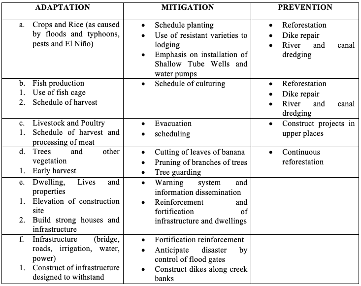
Improve community resilience to climate change through the development of sustainable rural livelihoods;
Restore forest in Upper elevated areas catchments to reduce siltation and the associated water flow problems;
Improve agricultural production under unpredictable rains and changing climatic conditions;
Improve the Municipality’s preparedness to cope with droughts and floods;
Improve climate monitoring to enhance early warning capability and decision- making along Agno River.